

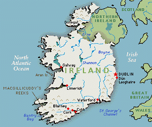
 Ireland, the westernmost and second largest of the British Isles, is
in the North Atlantic Ocean, and is separated from Great Britain by Saint
George's Channel on the southeast, the Irish Sea on the east, and the North
Channel on the northeast. Politically, the island is divided into Northern
Ireland, a constituent part of Great Britain, and the Republic of Ireland,
formerly Eire. The island is divided into four historical provinces-Connaught
(Connacht), Leinster, Munster, and Ulster-and administrative units called
counties. The Republic of Ireland consists of Connaught, Leinster, and
Munster provinces, totaling 23 counties, and in the north, 3 counties of
Ulster Province.
Ireland, the westernmost and second largest of the British Isles, is
in the North Atlantic Ocean, and is separated from Great Britain by Saint
George's Channel on the southeast, the Irish Sea on the east, and the North
Channel on the northeast. Politically, the island is divided into Northern
Ireland, a constituent part of Great Britain, and the Republic of Ireland,
formerly Eire. The island is divided into four historical provinces-Connaught
(Connacht), Leinster, Munster, and Ulster-and administrative units called
counties. The Republic of Ireland consists of Connaught, Leinster, and
Munster provinces, totaling 23 counties, and in the north, 3 counties of
Ulster Province.
 Northern Ireland consists of 26 districts, the remainder of Ulster Province.
The area of the island is 84,431 sq km (32,599 sq mi) (Republic of Ireland,
70,283 sq km/27,136 sq mi; Northern Ireland, 14,148 sq km/5463 sq mi).
The population of the island (1981) is 4,925,364, including the Republic
of Ireland (3,443,405). In a northern and southern direction, the maximum
length of Ireland is 486 km (302 mi); its extreme width is 280 km (174
mi). Malin Head, at latitude 55ş27' north, and Mizen Head, at latitude
51ş27' north, are, respectively, the northernmost and southernmost points
on the island; easternmost and westernmost points are demarcated by longitude
5ş25' west and longitude 10ş30' west.
Northern Ireland consists of 26 districts, the remainder of Ulster Province.
The area of the island is 84,431 sq km (32,599 sq mi) (Republic of Ireland,
70,283 sq km/27,136 sq mi; Northern Ireland, 14,148 sq km/5463 sq mi).
The population of the island (1981) is 4,925,364, including the Republic
of Ireland (3,443,405). In a northern and southern direction, the maximum
length of Ireland is 486 km (302 mi); its extreme width is 280 km (174
mi). Malin Head, at latitude 55ş27' north, and Mizen Head, at latitude
51ş27' north, are, respectively, the northernmost and southernmost points
on the island; easternmost and westernmost points are demarcated by longitude
5ş25' west and longitude 10ş30' west.
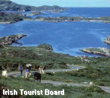
The eastern coast of Ireland is comparatively regular and has few deep
indentations; the western coast is fringed by drowned or submerged valleys,
steep cliffs, and hundreds of small islands torn from the mainland mass
by the powerful forces of the Atlantic. Topographically, the surface of
the island may be described as basin-shaped. The chief physiographic features
are a region of lowlands, occupying the central and east central sections,
and a complex system of low mountain ranges, lying between the lowlands
and the periphery of the island. Among the principal ranges are the Mourne
Mountains in the northeast, rising about 610 m (about 2000 ft) above sea
level; the mountains of Donegal in the north, containing Mount Errigal,
752 m (2466 ft); the Sperrin Mountains in the northwest, containing Sawel
Mountain, 683 m (2240 ft); the Maumturk Mountains in the west, containing
Mount Twelve Pins, 730 m (2395 ft); the Caha Mountains in the southwest,
containing Mount Knockboy, 707 m (2321 ft); the Boggeragh Mountains in
the south, rising to more than 640 m (2100 ft); and the Wicklow Mountains
in the east, rising more than 915 m (3000 ft). Carrantuohill (1041 m/3414
ft above sea level), located in the southwestern section of the island,
is the highest point in Ireland. 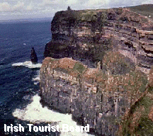 The
central plain, or lowlands region, has an extreme length of about 160 km
(about 100 mi) from east to west and a maximum width of about 80 km (about
50 mi) from north to south. Numerous bogs and lakes are found in the plain.
The principal rivers of Ireland are the Erne and the Shannon, which are
in reality chains of lakes joined by stretches of river. The northern portion
of the central plain is drained by the Erne River, and the center of the
plain is drained by the Shannon, which empties into the Atlantic Ocean
through a wide, lengthy estuary. Nearly half of the Shannon, above the
estuary, is made up of Allen, Ree, and Derg lakes. All the principal rivers
of Ireland flow from the plain, and an interior canal system facilitates
communications.
The
central plain, or lowlands region, has an extreme length of about 160 km
(about 100 mi) from east to west and a maximum width of about 80 km (about
50 mi) from north to south. Numerous bogs and lakes are found in the plain.
The principal rivers of Ireland are the Erne and the Shannon, which are
in reality chains of lakes joined by stretches of river. The northern portion
of the central plain is drained by the Erne River, and the center of the
plain is drained by the Shannon, which empties into the Atlantic Ocean
through a wide, lengthy estuary. Nearly half of the Shannon, above the
estuary, is made up of Allen, Ree, and Derg lakes. All the principal rivers
of Ireland flow from the plain, and an interior canal system facilitates
communications.
The climate of Ireland is typically insular. Because of the moderating influence of the prevailing warm, moist winds from the Atlantic Ocean, the mean winter temperature ranges from 4.4ş to 7.2ş C (40ş to 45ş F), approximately 14ş C (25ş F) higher than that of other places in the same latitude in the interior of Europe or on the eastern coast of North America. The oceanic influence is also very pronounced in summer, the mean summer temperature of Ireland, 15ş to 16.7ş C (59ş to 62ş F), being approximately 4ş C (7ş F) lower than that of other places in the same latitudes. The rainfall averages 1016 mm (40 in) a year.
The flora of Ireland comes largely from England (it originally came to England from the western portions of the European continent.) Sedges, rushes, ferns, and grass are the principal flora. The Irish fauna does not differ markedly from that of England or France. The great Irish deer and the great auk, or garefowl, were exterminated in prehistoric times; and, since civilization took root in Ireland, the island has lost its bear, wolf, wildcat, beaver, native cattle, and other species of animals. Remaining are the small rodents of the woods and fields and such small birds as belong to the fields, gardens, and shore. No serpents are found in Ireland, and the only reptile is the lizard.
 The
Shannon-Erne Waterway
The
Shannon-Erne Waterway 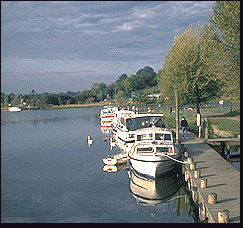 The
reopening of the old Ballinamore-Ballyconnell Canal has revitalized a facility
and a hinterland rich in natural beauty. Linking the renown Shannon and
the Erne, the waterway weaves together the streams, rivers and lakes which
are picturesquely scattered between Leitrim Village Ireland and the Erne.
Passing under 34 stone bridges it is checked by 16 locks on it's scenic
course through wild, unspoiled countryside. Each lock takes about 15 minutes
to negotiate and cruising time for the 62.5 kilometers of navigation is
approximately 13 hours.
The
reopening of the old Ballinamore-Ballyconnell Canal has revitalized a facility
and a hinterland rich in natural beauty. Linking the renown Shannon and
the Erne, the waterway weaves together the streams, rivers and lakes which
are picturesquely scattered between Leitrim Village Ireland and the Erne.
Passing under 34 stone bridges it is checked by 16 locks on it's scenic
course through wild, unspoiled countryside. Each lock takes about 15 minutes
to negotiate and cruising time for the 62.5 kilometers of navigation is
approximately 13 hours.
During the 18th century and first half of the 19th century, a web of waterways was established in Ireland including the Newry Canal, the first watershed canal to built in Ireland or Britain.
Although some work to make the Woodford River navigable began in the last decade of the 18th century, it wasn't until 1846 that excavations commenced in earnest on the Ballinamore-Ballyconnell Canal. The linking of the rivers and lakes with sections of still water was undertaken by the engineer, John McMahon. By the time his project staggered towards completion some 14 years later, the needs of drainage had triumphed over the navigational imperatives and cost cutting had resulted in leakages and collapsing banks. Only eight boats haltingly negotiated the navigation in its short nine-year history. Finally, in 1869 the canal was abandoned as the age of the steam train came into its own.
When the restoration project was undertaken a few years ago, 120 years of neglect had reduced the waterway to a sad, weed-choked channel of broken bridges and missing locks. Using the original sites and stonework, the bridges are now restored, the waterway is navigable for modern pleasure cruisers and the new locks are operated by a push-button electro-hydraulic system.
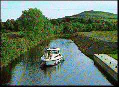 The
still water canal section negotiates a series of 8 locks which provides
a stairway from the Shannon to Lough Scur, a natural lake of great beauty.
The dominant height in the area is the cairn-topped Sheemore, from which
point there is a panorama embracing over 30 lakes. Sheemore, together with
its sister hill, Sheebeg, provided O'Carolan, the 17th century blind harper
with the title for a haunting Irish air which you are likely to hear in
one of the music pubs as you travel.
The
still water canal section negotiates a series of 8 locks which provides
a stairway from the Shannon to Lough Scur, a natural lake of great beauty.
The dominant height in the area is the cairn-topped Sheemore, from which
point there is a panorama embracing over 30 lakes. Sheemore, together with
its sister hill, Sheebeg, provided O'Carolan, the 17th century blind harper
with the title for a haunting Irish air which you are likely to hear in
one of the music pubs as you travel.
The descent to Lough Erne is checked by another 8 locks and the waterway visits the angling towns of Ballinamore and Ballyconnell, towns which gave their names to the original canal. A barge marina marks the final lock as the Woodford River noses its way east to join Lough Erne.
No large cities or major industries mar the landscape along the canal's pleasant course. Reed banks thrive in the lakes and hedgerows parcel the pleasant fields, providing refuge for a great variety of wildlife. Wild flora decorates the banks and moors, delighting the senses.
Long before recorded history, early man marked the landscape with mysterious monuments in stone. These, together with early Christian establishments, punctuate the landscape.